Hiking trails and sights
Nature trail-playground for children (0.5 km)
The trail meant primarily for the smaller visitors is located by Lake Ähijärv next to the Visitor Centre of Karula National Park. The playground has a slide-observation tower, swings, a sandbox and a rope carousel. On the trail, it is possible to get to know erratics and rocks, differentiate between coniferous trees and broadleaf trees and get acquainted with the bird species living in the surrounding area, eggs and nests of the birds, the nature of the soil and the tracks of the mammals with the help of information boards.
Ähijärve path trail (4 km)
The trail starts and ends on the shore of Lake Ähijärv near the Visitor Centre of Karula National Park. The Ähijärve path trail, like the name indicates, runs mostly on previous and current paths and roads – pasture paths, shore or bank paths, foot paths, winder roads, horse roads and forest paths. You can see the relief, forests and farm landscapes of Ähijärve in the Karula Upland. Picturesque views on the lake from the northern shore of Lake Ähijärv are very enjoyable. The trail passes swimming places and Veski campfire site, it takes approximately 1.5 hours to pass the trail. The trail is marked with signs and 13 information boards.
Peräjärve forest trail (4 km)
The trail leads through several forest types – mesotrophic boreal forests, oligo-mesotrophic boreal forests, oligotrophic boreal heath forests, oligotrophic bog forests and Calla swamp forests. The trail passes Lake Peräjärv, a small forest lake that is silting up, Hundiauk, Säitsmepõrguorg Valley, Paruni spring and ends on the Lossimägi Hill. You will obtain a good overview of the different usage of forests over time, a good example is the tapped pines growing near the hiking trail. The trail is marked with signs and 15 information boards introducing the trail points. It takes about 2 hours to pass the hilly hiking trail. The trail starts and ends in the parking lot of the Perajärve campfire site.
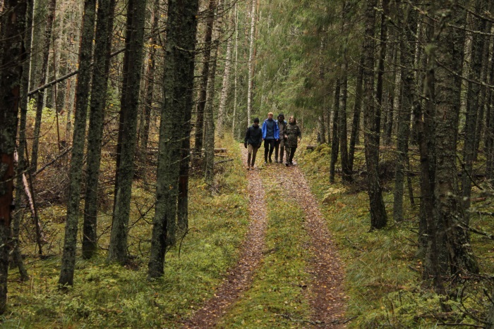
Hikers, Peräjärve forest trail. Helen Kivisild
Rebäse landscape trail (7 km)
The trail introduces various landscapes characteristic to the Karula area and their formation. The trail starts and ends in the parking lot of Tornimägi. The hikers can climb the local Ararat (103.1 m above sea level), see Lake Raudjärv with ice-cold water and pass the oldest farmstead in the neighbourhood which was first mentioned in 1586, and go to the ancient Linnamägi Hill. On the slope of Tornimägi Hill, you can see the biggest gullies of the Karula Upland. Tornimäe observation tower in Rebasemõisa Village offers a great view on the Otepää, Haanja and Aluksne Uplands; Kaika hillocks can also be seen (Tornimäe observation platform will be opened in 2018, it is closed at the moment). The trail is marked with signs and 15 information boards. The trail passes herded areas, it takes approximately 3 hours to pass the trail.
Karula long hiking trail (36 km)
The long hiking trail runs on the beautiful landscape of Karula in a circle. There is no definite start and end of the trail, it is possible to hike both ways following the signs. When hiking counter-clockwise, you will see magnificent views and the trail is easier to pass. The hiking trail passes through Veski, Mäekonnu, Õdri, Rebasemõisa and Plaagi campfire sites and Suuremäe camping area.
Karula short cycling trail (15 km)
Karula short cycling trail runs on the small roads of the enjoyable hillock landscape of Karula between fields and forests and then goes from Lake Ähijärv to the Kaika Village between the hillocks. On Kaikamäe Hill, you can rest and enjoy the beautiful views on the hillocks. Then the trail leads to Mähli Village, Mäekonnu observation tower and back to Lake Ähijärve. The best way to start passing the trail is at the Visitor Centre of Karula National Park where your can park you car. The trail is marked with tin and plastic bicycle markings.
Karula long cycling trail (38 km)
Karula long cycling trail runs on the small roads of the enjoyable hillock landscape of Karula between fields and forests. There is no definite start or end point of the cycling trail. The best way to start passing the trail is at the Visitor Centre of Karula National Park where you can park your car and get a map of the national park from the information point. The trails are marked with tin and plastic bicycle markings. Tents can be set up in Rebasemõisa campfire site.
Peraküla-Aegviidu-Ähijärve hiking route of the State Forest Management Centre (820 km)
Peraküla-Aegviidu-Ähijärve hiking route of the State Forest Management Centre passes through nine counties and many protected areas and shows a lot of wonderful landscapes of Estonia in its 820 km. The start or end of the long hiking route is at Lake Ähijärv. The route is marked with direction indicators and white-green-white colour markings.