Cultural history of the region
There used to be five villages in Soomaa, three of which remain today.
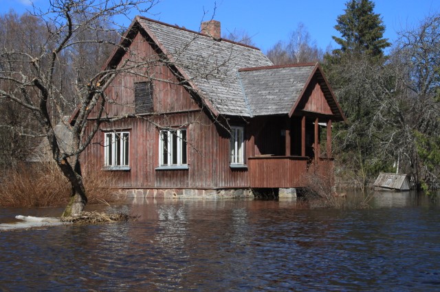
Riisa village has been inhabited since the Stone Age, with the first written reports dating back to 1599. The village reached its peak during the pre-war Republic of Estonia, primarily focusing on dairy cattle farming and the sale of dairy products. The village had its own dairy, primary school, shop, there was a drama circle, a string orchestra, and several societies. Today, the settlement has been preserved in the central part of the former village. The oldest known building in Soomaa is also located in Riisa – the small barn of the Adojaani farm is dated to 1753 using the dendrochronology method. In the village of Riisa, on the Halliste River, the Riisa hydrometric monitoring station of the National Weather Service has been located for more than 100 years.
Sandra village runs along the banks of the Lemmjõe and Raudna rivers and is the largest village in Estonia in terms of area (173 km²). The Sandra farm, which was founded in the first half of the 18th century and was the largest farm in the village, housed the Sandra school for a while after the Second World War. The village was home to the Oksa or Särgoja tavern, built by the Lahmuse landlord in the middle of the 19th century. The tavern was open only in winter. Today, only the mantle chimney has survived from the impressive building.
Tipu village is the youngest of the villages in Soomaa. The predecessor of the village was the Halliste village by a river bearing the same name. The first reports of the village date back to 1811. However, the village is considered to have been formed in the 1860s when the landlord of Kõpu, who managed the forests, built a sawmill there and allowed the peasants to settle in the area. Thanks to the sawmill, Alexander von Sryk, the landlord of Suur-Kõpu, had the Kõpu-Tipu road built. The only underground cemetery in Soomaa, which dates back to the second millennium BCE, is located in the village.
The schoolhouse in Tipu village was built in 1932 to replace the former sawmill. In the best of times, 40–50 children were taught there. The schoolhouse was closed in 1964 due to a shortage of students. From then on, the residents used the schoolhouse as a community centre and a library. The University of Tartu used the building as a training base since 1968. Since 2009, MTÜ Tipu Looduskool has been operating in the former school building, providing environmental knowledge to those interested.
There are written reports of the former Tõramaa village (part of the current villages of Riisa, Sandra, and Tipu) from 1839. A distinction was made between Tõramaa village in Pärnu County and Kõpu-Tõramaa in Viljandi County. However, the former village lost its last residents in 1979, and the latter lost its residents in 1996. Of the buildings, only the Pärna farmhouse, the old basement of Abaja farm, and the ruins of the old barn-dwelling of Üleoja and the ruins of the gorgeous basement of Murru have survived. The visitor centre of RMK Soomaa National Park is also located in the former village of Tõramaa, in Kõrtsi-Tõramaa, in the current village of Tipu.
The former Toonoja village (currently part of Karjasoo village) is located in the middle of Kuresoo bog. The village, which was located in Rabasaare, was formed at the beginning of the 19th century. At the time, Toonoja had six viable farms, and the lands of the village were largely cultivated. The last resident left Toonoja in 1987. Of the once vibrant village, only a few farmsteads, a root cellar, and the Mardi farm building remain.